He's tall, he's strong, and sometimes he can be a little exuberant. His last rage was in 1909. We are talking about the Teide, of course, the 3718m volcano that sits in the center of the island of Tenerife! His silhouette can be seen from almost everywhere, but it is best to approach him, to discover his Mineral universe, to tread down with his feet the burns and scars that he left to nature around him.


Length and duration: count 45 minutes of quiet walk to walk the 2km.
For the first time, we went to the foot of the Teide for a simple car ride, without really knowing what to expect. We enjoyed the landscapes so much that we returned three more times, equipped for more and more difficult hikes, until we climbed to the top of the volcano on foot, the best memory of our stay in Tenerife!
Climbing at the foot of the Teide, already an experience
The Teide volcano is protected by a national park that extends over one-tenth of the island. Or maybe it's the other way around: the park protects the inhabitants from a possible volcano mood swings. This park is located about 2000m above sea level, which is almost an hour's drive from our headquarters in San Cristóbal de la Laguna. But not the time to get bored: the landscapes make the show all the way!

We usually leave the Laguna under heavy clouds. The road climbs straight up and enters a majestic Canarian pine forest. And then, as we ascend, we find ourselves engulfed by the clouds. The atmosphere is eerily fascinating.
As we continue our ascent, the sun ends up piercing the fog and imposing itself for good. Several strategically located watchtowers allow you to discover the landscapes that run towards the ocean on each side of the road. Sometimes a sea of clouds obstructs the view, making the experience even more unforgettable.
A few thousand pine trees later, we enter the National Park. This is the moment the Teide volcano chooses to reappear in front of us.
Most of the way is accomplished, yet it still seems as far away. Around us, the sun revives the colors: the red and black hues of the Earth, the intense blue of the sky, the dazzling white of the clouds, the Green of the pines and the innumerable tufts of yellow, pink and blue flowers.…
Surprisingly, the slope reverses. The road goes down. She drops us at the bottom of the Caldeira, a giant cauldron. This term used by volcanologists around the world was invented here. The caldera of Teide tells us an old story, that of an ancient volcano called Cañadas, much larger than the Teide, which one day collapsed on itself. Crack. Once everything settled down, the Teide resurfaced from the Caldeira, accompanied by a few smaller friends.
The landscapes of the Teide's Caldeira are difficult to describe. Dry and mineral. They remind us of our holidays on Mars (article to come, accompanied by our good plans for cheap rocket tickets).
In order to make it possible to wander among the different types of magmatic rocks, several car parks are located along the only road that crosses the Caldeira. You notably stop near a large area of malpaís, a term used by the locals which translate as "bad country". The soil is spiked with rocks so hard and so sharp that you have to give up all idea of exploiting it. Volcanologists, these jokers, use the Hawaiian term lava a'a.…
Hiking in the Teide Caldeira
As for the hiking trails, Teide National Park has nothing to envy to the Anaga massif. We have realized two beautiful steps in the Caldeira, whose routes :

1. The short but impressive hike of the Roques De García (in blue on the map)
This peaceful walk of about an hour takes you on a loop in the middle of surprising rock formations, the Roques. A good way to discover the bio-geo-volcano-mineralogical treasures of the Caldeira, without too much force on the calves!
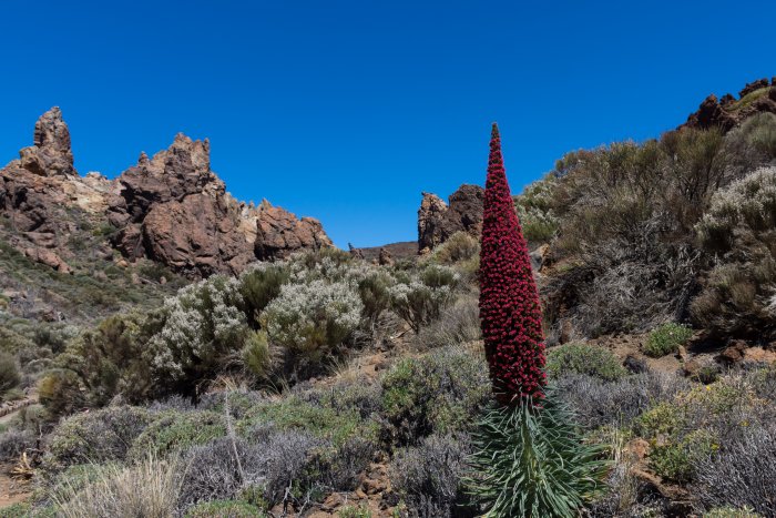
This giant stalk full of red flowers is emblematic of Teide Park. It is called red viperine, or tajinaste rojo in Spanish and measures within two or three meters. It was towards the end of the month of May that he must come to see it in flower.
Practical details on the hike of the Roques De García
Loop route: Yes
Difficulty: this is an easy hike that suits everyone. A small portion is even equipped for wheelchairs and strollers. Bring sunscreen and water.
Starting and finishing point: parking du Mirador de Ucanca. There are buses carrying tourists from hotels in the south of Tenerife, but rest assured, they take some pictures and leave also dry, without undertaking the hike. To come, it is better to have a car, public buses are too rare.


Loop route: no
2. The long hike of the Siete Cañadas (in the red on the map)
This hike goes along the beautiful cliff of the caldeira in an arid and Rocky setting. A kind of desert crossing whose landscapes perhaps end up looking a bit monotonous. It will appeal to good walkers looking for unusual scenery.
Length and duration: we have carried out this hike of 17km in 4H approximately without lunch break.
Difficulty: the trail is wide, flat and low. In contrast to the bright sunlight. We can only recommend that you come early in the morning and bring plenty of water.
Starting point: Parking of the hotel Parador de Cañadas del Teide or the church, the only one in the area. Follow trail # 4.
Arrival: point the place called El Portillo and the restaurant of the same name. The restaurant has parking, but public parking is 50m away. The starting and finishing points can be reversed without any problem. To avoid having the sun in your eyes, start from the Portillo in the morning, from the Parador in the afternoon.
Back to the starting point: friends joined us for this hike. So we positioned a car at each end of the road and the question didn't arise. Here are two other options:
- hitchhike.
- organize with one of the few buses. The Titsa 342 line is Parador → Portillo at 10.43 and Portillo → Parador at 15.10. The line Titsa 348 goes Portillo → Parador at 10h32 and Parador → Portillo at 16h.
Coming by bus: As above, you only have the choice between buses Titsa 342 if you live in the south and the Titsa 348 from Puerto de la Cruz or la Orotava. One way in the morning and one way back in the afternoon. It puts pressure on you to walk fast ! Tickets can be booked online here, at least 48 hours in advance.


-----------------------------------------
Attention: every year, two sheep hunting campaigns are organized, one in May-June and the other in October-November. The species was introduced by man, yet its ravages on the ecosystem are such that man regrets it. During these periods, national park trails are closed to hikers on Wednesdays and Fridays. Check with the office for exact dates.
The rise of the Teide on foot
The ascent of the volcano remains the best memory of our stay in Tenerife. We start at the level of the Caldeira, that is already 2200m won from the level of the sea. Still 1500m to climb!
The slope starts smoothly. We walk for a long time on small orange carvings. One wonders if the volcano would not be just a huge pile of sand. Soon, we meet our first Blue viperines, smaller than the Reds. They obviously appreciate the calm and the view, in this incline desert.
The sun is pounding. The path narrows. The slope increases. The ground is now strewn with dark and tortuous volcanic rocks. The lizards, with little fear, pull their heads out of their tuft of wildflowers to watch our runaway convoy pass.
The view is more impressive, strongly for the summit! But first, we have a night to spend. We reach the refuge Des 3260m early, less tired than expected and relieved to not feel any altitude sickness. Our housemates for the night arrive on our tracks, in small groups.
We rehydrate our dehydrated dinner, then stay for a long time in front of the refuge, watching the sunset, despite the temperature dropping and the wind rising.
At 4: 30 in the morning, all the alarm bells of the refuge ring in unison. We put on all the clothes we took with us, including scarves, gloves, and hats. The thermometer of the refuge indicates 6°C, from which it is probably necessary to remove a few degrees to know the temperature at the top of the volcano. We have 458 meters to climb before the sun appears at 7: 10. In reality, the most beautiful colors are those that gradually ignite the horizon in the thirty minutes before the star.
We're going, lights to the fronts. The path winds, more and steeper, towards the starry sky. Above, a narrow crater and a smell of sulfur await us. We land on a rock and wait for the show to begin.
As we go down, we come across a multitude of small fumaroles of sulfur vapors that we had not noticed in the dark. Just a reminder that Teide's volcanic activity will resume sooner or later. Don't cancel your visit, it is one of the best-monitored volcanoes in the world!
We take a little bit of regret the cable car that we had reserved for the descent, while we feel in shape to make it on foot.
Practical information about climbing the Teide on foot
Elevation gain and duration: the elevation gain is approximately 1500m. In detail, the starting point is around 2200m, the refuge at 3260m, the arrival point of the cable car at 3555m and the summit at 3718m. It took us three hours to get to the shelter, not to mention a long lunch break of an hour. The second part of the night took 1h20.
Difficulty: the altitude difference is important but we expected to be even harder. Our training in Anaga in the past weeks seems to have paid off! The main constraints are :
- The Sun that heats on the lower part,
- The cold on the High part (sometimes negative temperatures at the top at night),
- Weight in the back with water, food and things to wear,
- The oxygen that is becoming more scarce, which slows down the progression on the last part,
- The path that sometimes requires the help of hands.
Altitude: sickness we are uneven compared to altitude. The 3718 meters of the Teide can cause trouble for some. According to Wikipedia, 15% of the population suffers at 2,000 meters and 60% at 4,000 meters. So the risk is not so low. If this happens to you, don't be relentless and go down as fast as you can to avoid complications.
By car: the starting point of the trail is the car park of La Montaña Blanca, which is unfortunately often full from the beginning of the afternoon. There is another car park called Tabonal Negro 800m away and, at worst, the car park of the cable car 3km away. On the other hand, if you go down the cable car, you will be the first to get back to your car!
Coming by bus: there again is not easy as both bus lines 342 and 348 only pass twice a day. The morning hours may, however, be consistent with your return. See if you prefer to arrive by bus in the morning and take your time or by bus in the afternoon and walk fast.
The hut of the Altavista: is the only hut of the Teide and it has only fifty places in a dormitory. We can only advise you to reserve your spot several weeks in advance, especially in high season. This happens on this site, for a price between 21€ and 25€. Please print your reservation and bring an ID card, these documents will be required. Bed linen and warm duvets are provided and there is a kitchenette with plates, pans, and microwave. Tap water is not drinkable. Overpriced distributors sell chocolate bars and drinks. Finally, there are no showers. The refuge opens its doors at 5 p.m. and the dormitories at 7 p.m.
Cable car return: we have chosen to reserve our cable car seats for the descent of the Teide. This is an optional option when paying online for the shelter. We shouldn't have. Already, the downhill ticket can be bought at the top of the cable car at the same price (€13.50), no need to book. Then, because in case of altitude sickness or any other problem, the ticket is bought for nothing. And finally, because we felt fit and had enough water to go down on foot. The first cable car descends around 9am, so we waited almost an hour with the other hikers of the refuge.
Make the round trip in the same day: most of the walkers do as we do the climb in two stages, with a night at the refuge. It's not mandatory. If you feel like it, you can do it all in one day. Just know that the last stretch that leads to the summit is highly regulated and requires either to take it and leave it before 9: 00 AM or to have in its possession a permit of passage issued on this site. It is free but distributed in such a limited number that it must be done several months in advance.
Snow on the Teide: be careful, weather conditions sometimes prevent access to the summit, especially during snow events in winter.
Climb the Teide by cable car
We did not climb the cable car, but we gleaned some information for those who would like to go there. The cable car is taken every day between 9am and 5pm for a price of € 13.50 each way, € 27 each way. Booking is possible online here. Don't forget to bring warm clothing.
Attention, the cable car does not take you to the summit, it stops at 3555m of altitude. From here, you will still have a superb view of the Caldeira and access to two trails (N°11 and 12) to stretch your legs. On the other hand, access to trail No.10 which leads to the top of Teide is restricted. The tip would be too narrow to accommodate all-day visitors. If you want to climb the last 163 meters, you have to apply for a permit and especially take several months in advance as there are so many candidates. This is happening on this site.
Comments
Post a Comment